Bart Holterman, 22 December 2017
Mike Belasus, with Kevin Martin and Bart Holterman
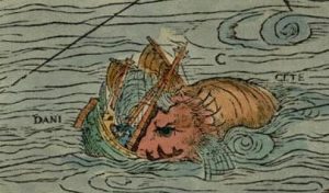
Detail from Olaus Magnus Carta Marina 1539: The ship-destroying sea monster is symbolising the perils of a journey across the open ocean.
A Project on the Low German merchants’ trade from Bremen and Hamburg with the North Atlantic islands is not complete without the vessels that made trade across the ocean possible. The written sources tell us that many German ships were lost along the coast of Iceland, but until today, not a single mentioned shipwreck was found. This is not surprising, given the circumstance that underwater archaeology in Iceland is not even twenty years old.
Some facts about finding shipwrecks
The saying “Searching for a needle in a haystack” is fitting pretty well to the search for shipwrecks mentioned in historical documents, considering the abilities to determine a ship’s position in the past and the fact that 71 % of Earth’s surface is covered by water. Even today, many ships vanish without a trace. On top of that, the number of archaeologists looking for certain shipwrecks is extremely low. Therefore, most shipwrecks are found by accident and they remain more or less anonymous.
However, technology has improved and the potential for finding shipwrecks is much higher today than in the past. A number of devices can be used and combined for surveying the sea floor. A common combination is a side-scan sonar and a number of magnetometers, but this is still no guarantee for finding wrecks. When a ship is too decayed, or has settled into the sediment, the sound-rays of the side-scan sonar will not be able to produce a recognisable image. Moreover, magnetometers will not detect anomalies from the earth’s magnetic field when there is not enough metal on board the ship. Especially for medieval ships and early modern merchant vessels without guns, this can easily be the case. A sediment sonar could be a solution, which measures changes of density in the sediment with sound signals. The disadvantage is that waterlogged wood has the same density as waterlogged sediment. If a shipwreck has no denser cargo or ballast on board, the sonar will not detect density changes. Therefore such ships will remain hidden, even if an area is surveyed. Divers might be suggested as a final solution but a diver’s operating range is very limited, as he/she depends on depth, weather conditions, visibility and air supply.
The fact is that archaeologists rely in most cases on coincidences, which is how most of the known shipwrecks were found. The reason for this is that many other professions like builders, fishermen, geologists etc. spend much more time working on the sea floor than archaeologists, and sometimes stumble upon a wreck. One famous example for this is for example the “Bremen Cog” in the German Maritime Museum in Bremerhaven. A suction-excavator operator found it in the river Weser close to Bremen, when he was working on an extension of the riverbed. It became one of the most important finds in ship archaeology. Over the past decades, since underwater became an area of archaeological interest, hundreds of shipwrecks have been registered by the heritage departments of the German federal states but only a few of them could be identified by historical documents.
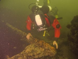
The author examining an anchor off the west coast of Gotland, at the site of the Visby-Disaster of 1566 (Photo: Jens Auer).
When we approach the shipwrecks from the historical documents, we have to realize that mentioned positions for lost ships are most of the time very vague. This situation can extend the search area dramatically without even knowing if the wrecks still exist as a coherent site. The conditions of the natural environment are vital to the survival of remains. Rugged coastlines, strong currents, micro-organisms, the chemical consistence of the water and the like can severely contribute to the decay of organic matter, metals and even certain types of stone. In the Mediterranean Sea, for example, ship hulls will not survive for a long time above the sea floor due to temperature, salinity and micro-organisms. Iron will soon vanish by the reaction with salt and oxygen and even marble and copper-alloys will decay. The opposite situation can be found in the Northern Baltic or the Sea Black Sea, for example. The Northern Baltic is deep, has a very low salt content and is cold. This prevents wood-decaying organisms to multiply and destruction from anchors or looting divers. The Black Sea water, on the other hand, has hardly any oxygen in a certain depth, which almost freezes time on the sea floor.
In addition, the circumstances of the sinking in connection to the natural environment play an important role. A German ship in Spanish service in 1588, the Gran Grifon, hardly left any structural remains. Another extreme example is the destruction of a united navy fleet of Lübeck and Danish ships during the Nordic Seven Years War on the west coast of Gotland in 1566. Out of thirty-seven ships, fifteen were lost and 6000 to 8000 sailors lost their lives in the so-called Visby-Disaster. Intensive archaeological diving surveys for several years could not reveal any wreck site. The ships literally vanished, most likely because they disintegrated in the storm on the rough sea floor and their remains were thrown up on the beach.
These examples shows us that a sunken ship mentioned in the historical documents does not always leave a proper wreck site. Sometimes scattered debris spread over square kilometres of sea floor can be all that is left of a ship.
The missing wrecks of Iceland

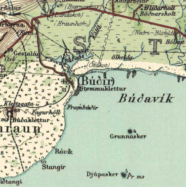
The site of the Bremen trading harbour Búðir/Bodenstede on the west coast of Iceland. It continued to be used by the Danes after 1601.
In theory, Iceland has a high potential for finding shipwrecks. Since the late 9th century, humans settle here and they had no other way than to cross the rough North Atlantic Ocean and make landfall on a rugged coast. Many ships, Norwegian, Danish, English, Low German and Dutch, evidently got lost on their route between continental Europe and Iceland. A considerable number of these found their end on the coast of Iceland, as we can read in the historical documents. Ragnar Edvardson has calculated a number of about 450 shipwrecks in Iceland, from the period from 1100 to 1900, most of which foundered on the West coast. Until today, no wreck from the period of the Low German trade has been found. The oldest ship found in Iceland is currently a Dutch merchantman, which sank in the harbour at Flatey in Breiðafjörður in 1659, and is currently under investigation by Kevin Martin. The scarcity of known shipwrecks in Iceland is not necessarily because they vanished completely, but because maritime archaeology is a very young discipline in this country and started only with sporadic projects from 1993 onwards. The relatively few inhabitants of Iceland also reduce the possibility of coincidental discoveries of wrecks due to the lack of building activities.
Vive la Coïncidence!
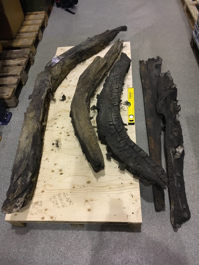
However, coincidences happen – even in Iceland. In 1998, an excavator hit timbers while digging a cable trench near Búðir on the Snæfellsnes peninsula in Western Iceland. They turned out to be fragments of a ship that was buried under the sand of an estuary. Some timbers and ballast stones were recovered by archaeologist Björn Stefánsson, and brought to the National Museum of Iceland in Reykjavik, were they were documented and put in storage. None of the recovered timbers was suitable for dendrochronological dating, but the ballast included stones that can possibly originate in Norway, Britain or Greenland. However, this does not give any indication were the ship was coming from, because ballast was taken from board and loaded in all harbours depending on the cargo and to adjust the angle of the ship in the water, to trim the ship. The recovered timbers give the impression of an old carvel-built ship. The material seems not to be of the finest quality, but this is hard to judge from only a handful of timbers. A promising fact is that Búðir was an important trading centre in Iceland for at least 200 years. It was already visited by Bremen merchants in the late 16th century, who called it “Bodenstede”. For a long time it was the main trading site for the Snæfellsness Peninsula, called first by cargo ships of the Low German merchants and later by Danish and Dutch ships. It was abandoned as a trading post in 1787.
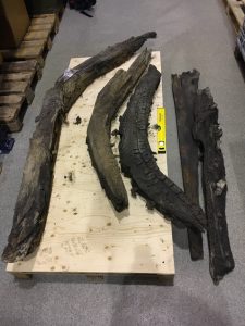
The recovered ship timbers from Búðir today at the National Museum of Iceland, Reykjavik (Photo: Kevin Martin)
For this reason, we have written sources on the activities on this site including the loss of several ships during these 200 years. The problem for the identification of the accidental found ship is the fact that there was not only one ship lost near the site. We know at least about eleven ships that are reported to have been lost at Búðir and its harbour Búðavik. Of those eleven ships, one was from Bremen. It belonged to the merchant Vasmer Bake and sank in or close to the harbour of Bodenstede in 1587. This was reported by Carsten Bake, his son, who himself was involved in the Iceland trade. In 1607, a Danish ship wrecked at Búðir. For 1666, another ship sank west of Búðir. More ships sank in this area in 1724, 1728 (Danish) and 1754, and lastly, Bjarni Sívertsen’s cutter, which got lost here in 1812.
Certainly, it is possible that the ship found in 1998 is Vasmer Bake’s lost vessel from 1587, but the timbers cannot give us any more detailed information. All we can say today about the few recovered timbers is that there are five floor timbers and two fragments with an unknown function. The floor timbers indicate that the cable trench hit the wreck most likely in the bow section, leaving most of the buried remains uncovered. Each plank was attached to each frame with at least two tree nails, and each frame was connected to the keel with one or two tree nails. The dimensions of the floor timbers vary a lot, from flat and wide to high and narrow. This might be an indication that whoever built the ship faced either a shortage of crooked compass timbers, or the building did not rely on an even framing in a shell based building method, or both. However, it can also not be excluded that we face the remains of Bjarni Sívertsen’s cutter from 1812. Only future investigations might give us an answer.
References:
Edvardson R. and Grassel Ph., The Potential of Underwater Archaeology in the North Atlantic. In: N. Mehler, Travelling to Shetland, Faroe and Iceland during the 15th to 17th centuries (in press).
Stefànson, B., Skipsviðir úr Búðaósi. Rannsóknaskýrslur fornleifadeildar 1998. Fornleifadeild þjóðminjasafns Íslands, Reykjavik 1998
Posted in: General, Reports, Stories
Bart Holterman, 7 September 2017
Bart Holterman presentated the project and his own research on August 5 in Haus der Wissenschaft in Bremen. Matthias Holthaus was there as well and wrote the following article about it in the Weser Kurier of August 21, which gives a nice overview of the situation German merchants had to deal with when trading in the North Atlantic in the late Middle Ages (in German).
https://www.weser-kurier.de/bremen/stadtteile/stadtteile-bremen-mitte_artikel,-reger-handel-mit-dem-hohen-norden-_arid,1638338.html
Posted in: Press
Natascha Mehler, 11 August 2016
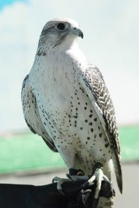
A white gyrfalcon on a falconer’s hand (Photo: Elena Gaillard, New York / Wikimedia Commons)
Throughout the medieval and early modern period, Icelandic gyrfalcons were highly valued at the courts of European rulers and they were worth a fortune. Indeed, Frederick II (1194-1250), Holy Roman Emperor, already noted in his treatise De arte venandi cum avibus that the best falcons for use in falconry were gyrfalcons (…et isti sunt meliores omnibus aliis, Girofalco enim dicitur). The reason for this was that of all falcon species, gyrfalcons (Falco rusticolus) are the largest and most powerful. Their plumage varies greatly from completely white to very dark, of which the white variety was the most valued hawking bird in the Middle Ages, and still is today. They only inhabit sub-arctic and arctic areas, with their highest population density in Iceland (one pair per 150-300 km²). During the breeding season (roughly February to June) there are today 200-400 nesting pairs in Iceland, and in the winter the population increases to 1.000-2.5000 individuals, due to migrating birds from Greenland.
Written sources from the 16th century, when German merchants from Hamburg and Bremen dominated the trade with the North Atlantic islands, give us a better insight into the falcon business with Iceland. Matthias Hoep, a Hamburg merchant, has left behind a collection of account books (1582-1594) which show us that he traded in many commodities such as fish, timber, and tools, and specialized in the trade of falcons. Hoep employed falcon catchers to catch birds in Iceland for him and he made specific contracts with them. The books record a great number of falcons and other birds of prey that he bought from falcon catchers and which he then sold on. On 5 April 1584, Hoep made a contract with the falcon catchers and brothers Augustin and Marcus Mumme which he commissioned to travel to Iceland to catch falcons. The contract specified the bird species, the conditions of the birds upon delivery, and the prices Hoep was going to pay after the successful return of the Mummes from Iceland:
“On 5 April [1584] I have dealt in my house with Augustin and Marcus Mumme, in the name of god, that they shall sail to Iceland in the name of god, and we agreed that I will give for each pair of falcons 11 ½ daler, and 2 tercel [male falcons] for 1 falcon, and what is blank shall be counted as a red [unmoulted] falcon. But what is white and moulted once, or moulted twice and beautiful, for those I shall give them 20 daler for each falcon and 10 daler for a tercel. But what has moulted three times we shall agree upon with good will, and if god and luck provides them with white falcons, I will give the one who catches them black cloth for a jacket of 2 ½ ells, all of this is validated with a denarius dei of 1 sosling each, and both brothers have promised with an oath to bring the best birds they can get and to take no birds away, neither in Iceland nor during the journey back, until they have all been delivered to me.“
Roughly five months later, in September 1584, the brothers returned from Iceland and handed over 49 birds to Matthias Hoep.
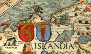
Detail of the Carta Marina (1539) showing the coat of arms of Iceland (stockfish), with a gyrfalcon (FALCO ALBI) above.
Later documents tell us how the shipping of the falcons was done. During the 17th century, a Danish falcon ship went to Iceland annually to transport falcons from Iceland to Copenhagen. The falcons were kept below the deck and sat on poles which were lined with vaðmál. During the journey, the birds were fed with meat of cattle, sheep or birds, dipped in milk, and when they were sick, they were fed with a mix of eggs and (fish) oil. Upon arrival of the birds in Hamburg, Mathias Hoep checked their health and quality and he considered them in good state after they had eaten three times and their feathers were not broken.
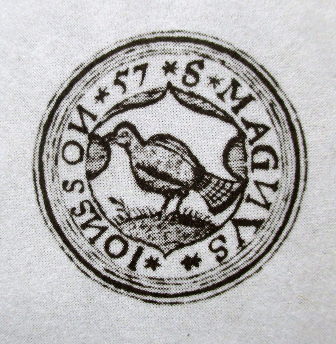
Most of the birds that Hoep received were sold to English merchants such as John Mysken who bought 55 birds of prey in 1584 and had them shipped to England, most likely to be sold to the English court. It is likely that Hoep also had good contacts with Icelanders, both in Iceland and in Hamburg. His professional network may have included Magnús Jónsson (c. 1530-1591), who had studied law in Hamburg, probably until 1556. In Iceland he became chieftain and sýslumaður (sheriff) at Þingeyjaþingssýsla and Ísafjarðarsýsla, districts in the North of Iceland with a very high density of falcons. No wonder his seal from the year 1557 shows a gyrfalcon in the centre.
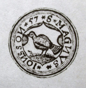
Seal of Magnús Jónsson, dated 1557. The priest Ólafur Halldórsson, a contemporary of Magnús Jónsson, described the seal in a poem: „Færði hann í feldi blá, fálkann hvíta skildi á, hver mann af því hugsa má, hans muni ekki ættin smá.” (transl. „he carried in a blue field, a white falcon on his shield, so that everybody shall think his family is not insignificant“).
In the second half of the 16th century, king Frederick II of Denmark-Norway (1559-1588) started to regulate the export of falcons to foreign countries. From the 1560s onwards, foreign falcon catchers needed to buy a permission (Icel. fálkabréf, falcon letter) to catch falcons.
Were falcons also caught in Shetland or the Faroes?
We have not found any written evidence for that. The obvious reason for this is that there are not many falcons around in Shetland and the Faroes. Gyrfalcons only appear as vagrant birds, and peregrine falcons (Falco peregrinus) exist in Shetland only in small numbers. However, it is worth pointing out that in the years 1601 to 1606 one Tonnies Mumme is recorded to have sailed each summer from Hamburg to Shetland. We do not know whether this is the same Tonnies Mumme that is reported as falcon catcher in Iceland in previous years, or whether Tonnies is related to the Augustin and Marcus Mumme mentioned above, but it seems very likely. He may have tried his luck in Shetland, or might have changed his profession and have traded in other items.
Further reading
Natascha Mehler, Hans Christian Küchelmann & Bart Holterman, The export of gyrfalcons from Iceland during the 16th century: a boundless business in a proto-globalized world. In: Gersmann, Karl-Heinz & Grimm, Oliver (eds.): Raptor and human – falconry and bird symbolism throughout the millennia on a global scale, vol. 3, Advanced studies on the archaeology and history of hunting 1 (Neumünster 2018), 995-1019.
Kurt Piper, Der Greifvogelhandel des Hamburger Kaufmanns Matthias Hoep (1582-1594). Jahrbuch des Deutschen Falkenordens (2001/2002), 205-212.
Björn Þórðarson, Íslenzkir fálkar. Safn til sögu Íslands og íslenskra bókmennta (Reykjavík 1957).
Posted in: Stories
Bart Holterman, 5 October 2015
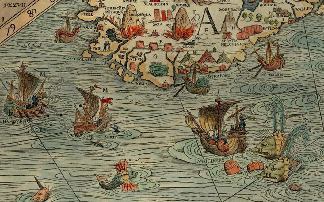
For the banner of this blog and our facebook page, we have displayed a section of the famous Carta Marina from 1539. On a first glance of the map, the many marvellous creatures that inhabit the land and the sea immediately catch the eye of the beholder, yet it also provides us with a good overview of the contemporary North Atlantic trade. Time to explore this remarkable document a bit further.
The map was made by Olaus Magnus (1490-1557), the brother of the last catholic bishop of Sweden. He had travelled Scandinavia and the lands around the Baltic Sea extensively before he was sent on a diplomatic mission to Rome by the Swedish king Gustav Vasa. He was never to return home. Dissatisfied by the Reformation in his homeland, Magnus stayed abroad, first in Lübeck and Danzig, later for a long time in Italy, soon joined by his expelled brother Johannes Magnus. In Italy he kept close contacts to learned men of his age, among others cartographers and travellers.
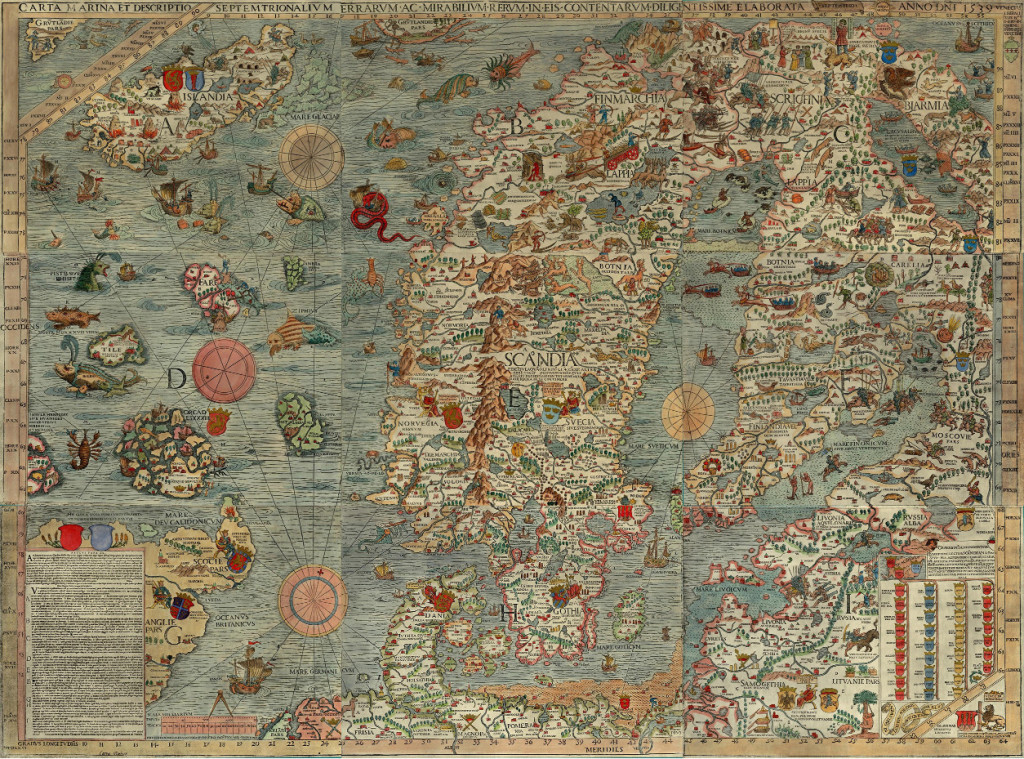
Under influence from these social circles, Magnus decided to transform his own knowledge about Northern Europe onto a map, which would appear in print in Venice in 1539. It was the first large-scale map of Scandinavia to be ever made, and had much influence on European cartography for the next decades. However, because of its high costs, the number of copies remained low. The map itself disappeared off the map of European learning, and was deemed to be lost since the late sixteenth century. Luckily in 1886 an intact copy of the map was discovered in the Bavarian State Library in Munich, and in 1961 another one, which now resides in Uppsala.
An explanation of the map appeared only in 1555 as Historia de gentibus septentrionalibus. In this book, Olaus Magnus described the geography, wildlife, and customs of the people of the North, illustrated with woodcuts. These woodcuts are clearly based on parts of the map, which includes many details about the people of the North, the political situation of the time, and the nature and wildlife. We can see kings sitting on their thrones, armies crossing the frozen Baltic Sea, people hunting seals, the most important towns and cities, lighthouses, whales attacking ships, enormous snakes, swimming cows and other sea monsters.
The map is divided into nine parts, marked A-I. It covers the entire Scandinavian peninsula, the Baltic, Northern Germany and the Netherlands, the entire North Sea and North Atlantic, including the coastline of Britain, the southern tip of Greenland and the mythical island Thule, known from classical geographical works. Of our interest are mainly the sections A and D, covering a large part of the North Atlantic.
Whaling on the Faroe Islands, from the Carta Marina (1539), photo: Wikimedia Commons
Olaus Magnus probably never visited the North Atlantic himself. Instead, he had to rely on the stories and descriptions of others, for example the Northern German traders that told him about Iceland, the Shetlands and the Faroe Islands. Of the Shetlands and Faroes, Magnus must have had few information, as these archipelagos are only schematically drawn. One remarkable detail can be found on the Faroes, though, where we can see a whale being slaughtered on the shore, reminiscing a practice of hunting whales by driving them up the shore which is still practiced today.
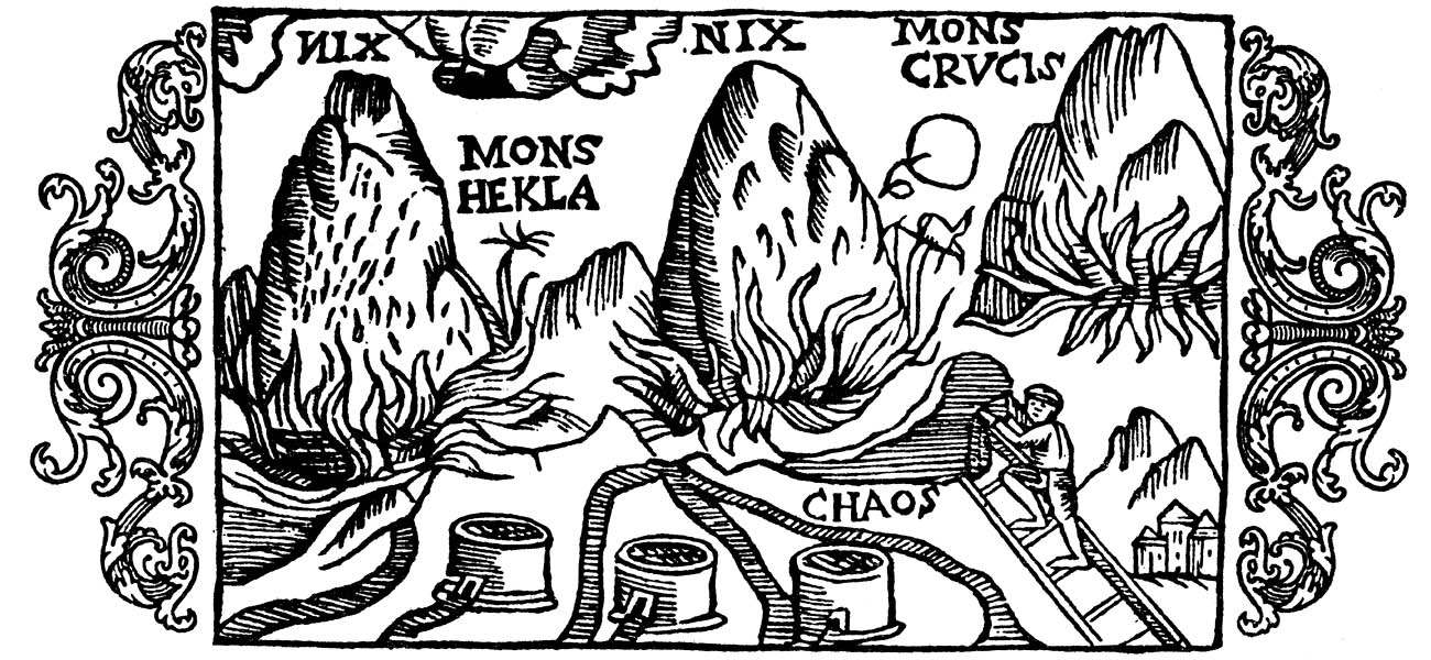
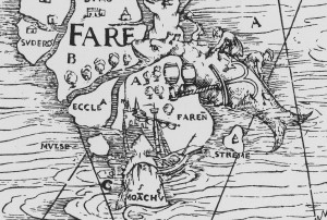
For Iceland, Magnus was clearly better informed. The Carta Marina was the first map that drew the island in its more or less actual shape. Moreover, three vulcanoes attest to Magnus’s knowledge of the high vulcanic activity on the island. The two episcopal sees, Hólar (Holensis) and Skálholt (Scalholdin), are displayed, as well as the monastery Helgafell (Abbatia Helgfiall), which was famed for its butter production (butirum). The three knights on the eastern part of Iceland should probably be seen as an indication of Danish military presence on the island.
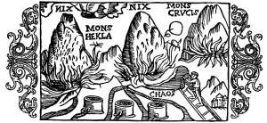
Three volcanoes on Iceland, from Historia de gentibus septentrionalibus (1555), photo: Wikimedia Commons.
Better than the natural, religious, and political situation, the map attests of the economic situation. Firstly, the main export goods of Iceland are indicated. These are, besides the already mentioned butter: stockfish, sulphur, and falcons. Stockfish was dried cod, highly valued in Europe as a preservable source of protein, and the main trade good of the arctic region. It is shown on a pile on the south coast. Just north of it, three containers of sulphur are depicted. Iceland was one of the few places where pure sulphur could be found. Sulphur, being among others a key ingredient for making gunpowder, was a highly valued substance. Finally, a gyr falcon (falco albus) can be seen on one of the northern peninsulas of Iceland. Gyr falcons are only found in arctic regions, and due to its being the largest and strongest species of falcon, it was highly valued by the nobility for use in falconry.
Apart from the export goods, the realities of the north atlantic trade are displayed in considerable detail on the map. Various trading harbours are indicated, most notably Hafnarfjörður (Hanafiord), where merchants from Hamburg had built a church. We can see ships lying at anchor at these harbours, and three tents at Ostrabord, which probably indicate the temporary booths the merchants set up on the shore and where they displayed their goods on sale during the summer.
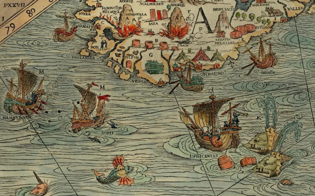
The most important countries and cities trading with the island are also indicated. We can see a ship from Bremen at anchor near Ostrabord, an English ship which confused a whale for an island, a ship from Lübeck being attacked by whales, and a Scottish ship under attack by one from Hamburg, indicating the dominance of Hamburg in the North Atlantic trade. It was no exception that competition between merchants from different places led to violent clashes, as in 1523, when the crews of ships from Bremen and Hamburg attacked an English ship in a conflict over the rightful ownership of an amount of stockfish, resulting in casualties among the English.
These elements make the Carta Marina a wonderful visual testimony of the North Atlantic trade in the sixteenth century.
Posted in: Sources